

The National Geodetic Survey (NGS), an office of NOAA’s National Ocean Service, manages a network of Continuously Operating Reference Stations (CORS) that provide Global Navigation Satellite System (GNSS) data consisting of carrier phase and code range measurements in support of three dimensional positioning, meteorology, space weather, and geophysical applications throughout the United States, its territories, and a few foreign countries.
Surveyors, GIS users, engineers, scientists, and the public at large that collect GPS data can use CORS data to improve the precision of their positions. CORS enhanced post-processed coordinates approach a few centimeters relative to the National Spatial Reference System, both horizontally and vertically.
The CORS network is a multi-purpose cooperative endeavor involving government, academic, and private organizations. The sites are independently owned and operated. Each agency shares their data with NGS, and NGS in turn analyzes and distributes the data free of charge. As of January 2014, the CORS network contains more than 1,900 stations, contributed by over 200 different organizations, and the network continues to expand.
DEDICATION
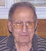 This station is dedicated to the memory of Rocco V. D’Andrea (1912-2003), who founded the land surveying and civil engineering firm Rocco V. D’Andrea, Inc. in 1947.
Rocco, a World War II veteran, was also a founding member and past president of the Connecticut Association of Land Surveyors, served on the State Board of Examiners for Surveyors and Engineers, while simultaneously building and operating a successful land surveying business, raising a family of ten children, and serving as an active member of numerous professional and community organizations. As Rocco’s son’s Tony and Len assumed a greater role in the daily operation of the company, along with daughter Alicia and youngest son Donald, Rocco found more time to enjoy his family and golf (usually with his wife, Eulie.) But, even after retiring in 1991 for health reasons, he was never very far from the office.
Rocco instilled professionalism in those who worked with him, seeking to provide the highest level of service to clients and the community. As a teacher and mentor, Rocco would forgive a young party chief’s mistakes and turn them into opportunities to learn and mature as a professional. As an employer, Rocco rewarded hard work and competence, and took pride in his employees. As an early adopter of new technology, Rocco was among the first to deploy in-house electronic computers, electronic distance measurement, total stations, electronic data collection and computer aided drafting (CAD).
Rocco’s main goal was always to do a better job. We think that sharing this data with the surveying and GIS communities, free of charge, benefits the public in this and neighboring communities. We’re sure that Rocco would approve.